top-news
Three Warnings Issued at Once! "Bavi" Re-Intensifies to Strong Typhoon Level; Latest Track Released
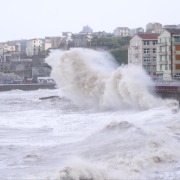
This year's No. 9 typhoon, "Bavi," intensified back into a strong typhoon at midnight today. At 6 a.m., the center of "Bavi" was located about 540 km east-southeast of the Zhejiang–Fujian border, with a maximum near-center wind force of 14.
The National Meteorological Center continued to issue an orange typhoon warning at 06:00 on July 11: "Bavi" is expected to move rapidly northwestward at 30–35 km/h with little change in intensity, gradually approaching the coasts of Zhejiang and Fujian. It is forecast to make landfall in the coastal stretch from Taizhou, Zhejiang to Fuding, Fujian in the early hours of July 12 (strong typhoon or typhoon level, 13–14 on the near-center scale, 38–45 m/s). After landfall it will turn northwest then north, with its intensity gradually weakening.
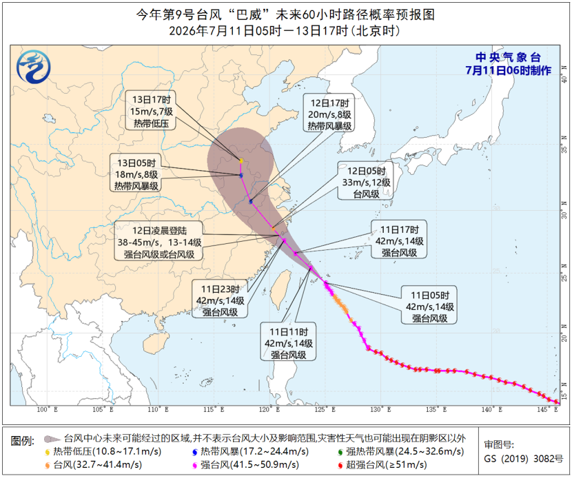
Forecast track of Typhoon "Bavi."
Gale forecast: From 08:00 on July 11 to 08:00 on July 12, winds across the southern Yellow Sea, most of the East China Sea and the waters near the Diaoyu Islands, the Taiwan Strait, the waters east of Taiwan, the Bashi Channel, the northeastern South China Sea, as well as the Yangtze River estuary, Hangzhou Bay, the Zhoushan Archipelago and nearby waters, and the coasts of Jiangsu, Shanghai, Zhejiang, Fujian and Taiwan will gradually strengthen to force 6–8. Among these, the northwestern and southern East China Sea, the waters east of Taiwan, the northern Taiwan Strait, and the Hangzhou Bay, the Zhoushan Archipelago, the coast of Zhejiang, the northeastern coast of Fujian, and the northern and eastern coasts of Taiwan Island and the waters near the Diaoyu Islands will see force 9–11 winds with gusts of 12–13. In the waters near the center of "Bavi," winds may reach force 12–14 with gusts of 15–16.
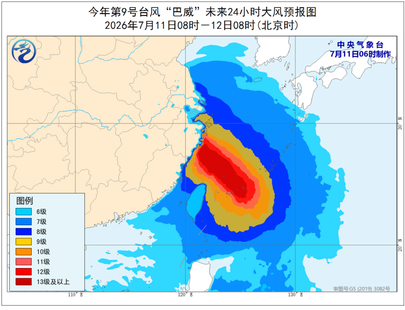
Forecast map of gale-force winds.
Precipitation forecast: From 08:00 on July 11 to 08:00 on July 12, Zhejiang, northern Fujian, Taiwan Island and other areas will see heavy to torrential rain. Parts of eastern and southern Zhejiang, northern Fujian, and Taiwan Island will experience extremely heavy rain (250–800 mm).
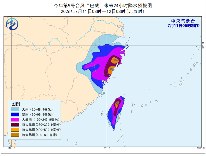
Forecast map of precipitation.
The National Meteorological Center continued to issue an orange rainstorm warning at 06:00 on July 11:
From 08:00 on July 11 to 08:00 on July 12, parts of Beijing, northern Tianjin, central and northern Hebei, southeastern Inner Mongolia, western and northern Liaoning, central and eastern Jilin, central and southern Shaanxi, southeastern Qinghai, southwestern Gansu, the western Sichuan Basin, Zhejiang, northern Fujian, northeastern Jiangxi, and Taiwan Island will see rainstorms. Among them, parts of Beijing, northern Tianjin, central and northern Hebei, northern Liaoning, eastern Jilin, the western Sichuan Basin, eastern and southern Zhejiang, northern Fujian, northeastern Jiangxi, and Taiwan Island will see heavy rainstorms. The northeastern part of Beijing and the northeastern part of Hebei will see localized extremely heavy rain (250–280 mm), while eastern Zhejiang, northeastern Fujian, and central and northern Taiwan Island will see extremely heavy rain (250–800 mm). Some of the aforementioned areas will be accompanied by short-term heavy precipitation (maximum hourly rainfall of 20–50 mm, locally exceeding 80 mm), with localized thunderstorms, strong winds, or hail and other severe convective weather.
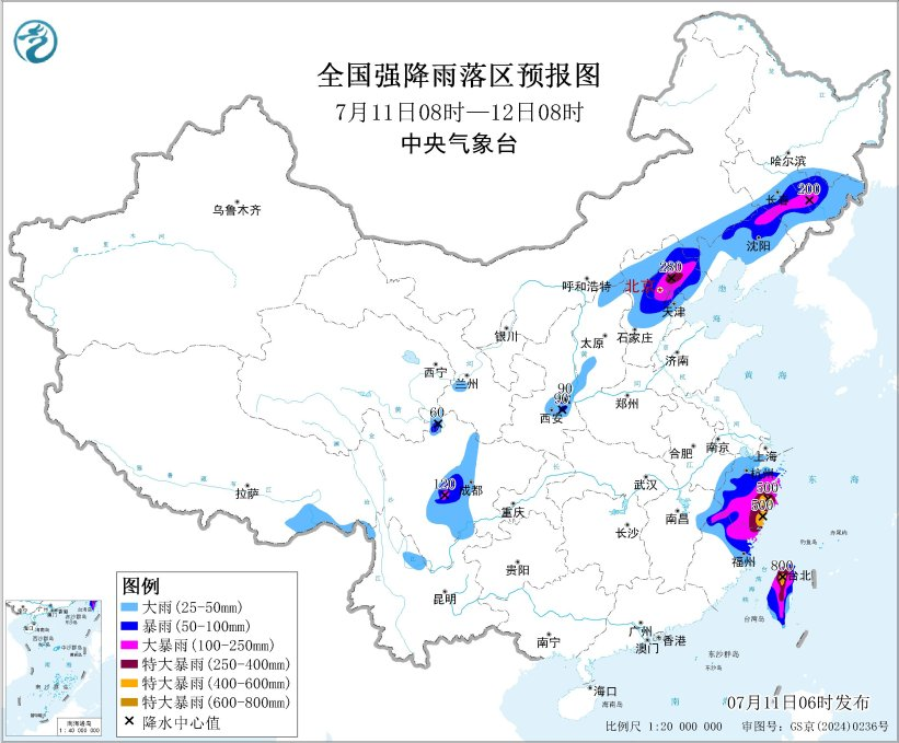
Forecast map of the rainstorm.
Defense guidelines:
- Governments and relevant departments should fulfill their duties and carry out emergency response work for heavy rain;
- Cut off dangerous outdoor power supplies and suspend outdoor operations;
- Units in hazardous areas should close schools and suspend business, and take special measures to protect the safety of students and children already at school as well as other staff;
- Drain urban areas and farmland properly, and guard against possible flash floods, landslides, mudslides, and other disasters.
The National Meteorological Center continued to issue a yellow warning for severe convective weather at 06:00 on July 11:
From 08:00 on July 11 to 08:00 on July 12, parts of western and southern Northeast China, central and northern North China, eastern Southwest China, and eastern Jiangnan will see thunderstorm winds or hail of force 8 or above. Among them, parts of central and western Liaoning, central Hebei, and eastern Zhejiang will see thunderstorm winds of force 10 or above, with maximum winds reaching force 11 or above, and the possibility of tornadoes in some areas cannot be ruled out. Parts of eastern Inner Mongolia, western and south-central Northeast China, central and northern North China, eastern Northwest China, eastern and southern Southwest China, and eastern Jiangnan will see short-term heavy precipitation exceeding 20 mm per hour. Among them, parts of north-central and southern Liaoning, central and northeastern Hebei, eastern and southern Beijing, northern and western Tianjin, eastern and southern Shaanxi, eastern and southwestern Shanxi, central-eastern and southwestern Zhejiang, and the southwestern Sichuan Basin will see hourly rainfall exceeding 50 mm, with a maximum of over 80 mm.
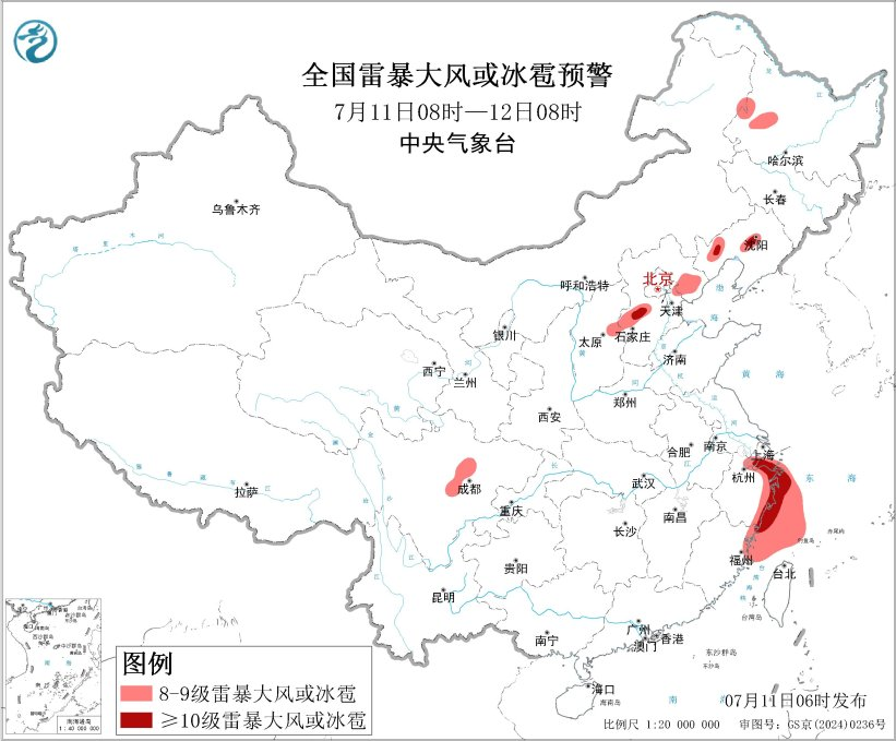
Severe convective weather forecast (1).
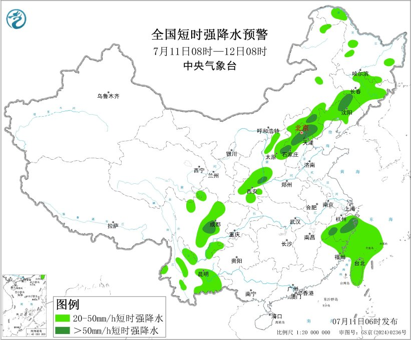
Severe convective weather forecast (2).
Defense guidelines:
- Governments and relevant departments should fulfill their duties and carry out emergency defense work against short-term heavy rain, lightning, and strong winds; meteorological departments should prepare for and conduct artificial hail-suppression operations when conditions allow;
- Drivers should slow down and proceed only after confirming safety when passing through flooded sections; traffic management departments should impose traffic control and guidance on sections with heavy rain and standing water;
- Outdoor personnel should reduce or suspend operations in open areas, take shelter in buildings with strong wind resistance and lightning protection, and close doors and windows while staying away from dangerous power sources;
- Airports, railways, expressways, and waterways should adopt measures such as flight and speed limits or temporary closures to ensure the safety of personnel and traffic; vessels operating in and passing through relevant waters should return to port for shelter and reinforce port facilities;
- Inspect the drainage systems of cities, farmland, and fish ponds, and take necessary drainage measures and prepare defenses against flash floods, landslides, mudslides, and other disasters.